


Mechanical engineering freshman Jose Hernandez woke up to UTA’s weather sirens at 5 a.m. Tuesday in his Arlington Hall dorm room.
Around the same time, an urgent MavAlert was sent, advising students to seek shelter immediately due to a tornado warning. Nearly 20 minutes later, a second message extended the shelter-in-place procedure. Around 5:40 a.m., a final alert was sent to announce that the tornado threat passed and the campus would resume normal operations.
“I found that annoying mainly because knowing this area, it doesn't seem that tornadoes are gonna hit this area as much,” Hernandez said about the sirens.
Yet, Hernandez still carried an umbrella. Many Dallas-Fort Worth residents, including UTA students, shared similar experiences — affected by the powerful winds, rain and dust throughout Tuesday.

A line of storms moved through Arlington producing severe thunderstorm winds from approximately 5 to 7 a.m. Tuesday.
“We’re starting, now, to get ready for our spring season, and usually with that we get different systems of winds through the region,” said Patricia Sánchez, National Weather Service meteorologist.
The storms began developing in West Texas and moved across North and Central Texas, causing widespread damage, Sánchez said.
Around 5 a.m., Tarrant County had 60 to 70 mph winds, she said. The threshold to issue a severe thunderstorm warning is 58 mph.

During business analytics graduate Andres Duenas’ usual 8:45 a.m. commute from Fort Worth to campus, Google Maps rerouted him to the back roads, delaying his trip by 15 minutes. But the weather impacted more than his drive.
“I also woke up during the whole night just because of the wind and the storm,” Duenas said. “I am a light sleeper, so I woke up like three times.”
When nursing sophomore Omonzefe Okhilu got to campus at 9:25 a.m., the wind was so strong she said that it almost made her fall.
“Next time, if I see wind on that weather app, I'm wearing tight-fitted clothes because this can't happen again,” Okhilu said, pointing at her baggy clothes and slim jacket.

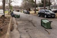
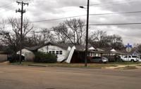
The storm path stretched across the Dallas-Fort Worth area, leaving trails of damage behind it.
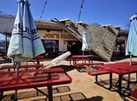
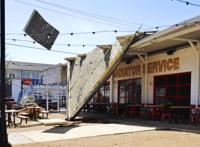
Around 10:30 a.m., Cane Rosso, a pizzeria on 200 N. East St., posted an image on Facebook showing damage to the restaurant’s roof.
According to an Oncor press release, the peak number of outages surpassed 335,000.
Approximately 80,000 outages have been restored and Oncor is currently working on the remainder. There are currently no estimated times for full power restoration.

The National Weather Service at Fort Worth/Dallas issued a high wind warning and wind advisory for areas near or south of Interstate 20 and areas along or west of Interstate 35 at 1:09 p.m. Tuesday.
Business analytics junior Dazzle Theruvath said her dad drove her to campus from Grand Prairie around 2 p.m., and she could feel how strong the wind was on the highway.
“Before we went the highway, like when we're going through a neighborhood, there's branches that fell off,” she said.
The high wind warning for the day estimated 30 to 40 mph winds with occasional 60 mph gusts and was in effect through 7 p.m. The wind advisory read 25 to 35 mph winds with gusts up to 50 mph through 9 p.m.
City of Arlington Public Works field crews responded to reports from residents about fallen trees and other debris on public roads and sidewalks. Workers also responded to streetlights, knocked over poles and power lines.
The storm has passed and is moving into Louisiana and Mississippi. Sánchez said Arlington should have quiet weather for the rest of this week.
@amandaLaldridge @hjgarcia0 @dangHLe @trinhvchristine